Gunnison Gorge Wilderness
Neighboring towns: Montrose, Gunnison, Cimarron, Crawford, Maher
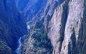
The Gunnison Gorge Wilderness is located nine miles northeast of Montrose and offers a wild
and pristine backcountry experience. A unique double canyon system of black granite
layered with red sandstones, the Gunnison Gorge Wilderness is located within
the Gunnison Gorge National Conservation Area just downstream from the Black
Canyon of the Gunnison National Park. The Gunnison Gorge Wilderness is only
the second BLM managed wilderness area in Colorado; it is managed to preserve and
protect its wilderness, scenic and recreational values.
Top of Page
User Fees
The Gunnison Gorge Wilderness is a participating site in the Recreation Fee Demonstration program.
User fees are required for both day use and overnight camping. Between 80 and 100% of the
fees collected in the Gunnison Gorge Wilderness will be used for resource and land management.
Gunnison Gorge User Fees
Visitors to the Gunnison Gorge Wilderness Area will be charged the following
user fees:
- Day Use Only (in and out the same day) = $3 per person
- Day Use & Camping = $5 per person per calendar day
- 1 night = $10
- 2 nights = $15
(maximum allowable stay)
- Annual Pass for Day Use - $15 per /year
Fees apply to all users, 16 years of age and older, within the river canyon from the
down-stream boundary of the Black Canyon of the Gunnison National Monument (2 miles
upstream of the Chukar Put-In) down to, but not including, the Smith Fork confluence (10
miles downstream of the Chukar Put-In).
There is no charge for private walk-in fishing or camping below the Smith Fork.
Voluntary donations are encouraged and can be placed in the register tube located at the
entrance kiosk.
Top of Page
Visitor Regulations
Specific regulations have been established to protect the Gunnison Gorge
Wilderness and all
visitors.
- One person, or the head guide of commercial trips, must register at the either the
Chukar put-in, Gunnison Forks, Bobcat, Duncan, or Ute trailheads (this requirement is
in addition to the fee permit).
- The maximum group size is 12 persons and applies to both day and overnight use.
- No wood fires are allowed. You must use either a camp stove or charcoal in a fire
pan. Pack out all ashes.
- Portable, reusable camp toilets are required.
- Camp in established campsites only.
- All dish water must be strained before returning it to the river.
- Maximum stay of 2 nights
- Pack out all trash (including cigarette butts) and human waste. A boater waste station
is located at the Gunnison Forks takeout for disposal of human waste.
- All commercial users must have a commercial permit issued by the BLM and must be
licensed by the State. All commercial users must have a current copy of the Special
Recreation Permit in possession.
- No motorized boats or jet skis are allowed upstream of the confluence with the Smith
Fork.
- No motorized vehicles or mountain bikes are allowed within the canyon rim of the
Gunnison Gorge.
Top of Page
Fishing Regulations
The following fishing regulations apply on the Gunnison River from the upstream
boundary of the Black Canyon National Park, through the Gunnison Gorge
Wilderness and downstream
to the confluence with the North Fork of the Gunnison River:
- Fishing by artificial flies and artificial lures only.
- All brown trout between 12 and 16 inches in length must be returned to the water
immediately.
- The bag, possession and size limit for brown trout is 4 fish, 12 inches in length or
less OR 3 fish less than 12 inches in length and 1 fish 16 inches in length or longer.
- All rainbow trout caught must be returned to the water immediately.
Top of Page
Flow Information
- Uncompahgre Field Office River Hotline: (970) 240-5388
Top of Page
Search and Rescue Information
- Delta County Sheriff - Dial 911 (non-emergency # 970-874-2000)
- Montrose County Sheriff - Dial 911 (non-emergency #
970-240-6606)
Top of Page
Boater Information
The Gunnison Gorge Wilderness offers a technical and remote experience for rafters, kayakers and
whitewater canoeists. The boating changes with every flow and is very dependent on winter
snowpack. Expect high spring releases of 2,000 to 10,000 cfs (Cubic Feet per Second) in
late May and early June. Summer flows very from 300 cfs in a very low water years to 2,000
+ cfs during big water years. At flows below 800 cfs the Gorge is very technical and is
not recommended for rafts over 12 feet in length. Flows over 5,000 cfs make the Gorge very
dangerous for boating. Currents become very swift and swirly, eddies disappear, and swims
are very long. Rescue is very difficult in the Gorge. If in doubt, SCOUT! See river
map for locations and class of rapids. Each raft must carry an extra oar or paddle , first
aid kit, repair kit and an extra PFD.
Located just down stream of the put in is Chukar rapid. Chukar is a single drop
class III. Most choose to run center at higher water and the right slot at lower flows.
Watch out for the pyramid rock center right thirty yards down stream. Next you encounter One
Miler rapid running left of the large center hole or rock depending on flows. Improvise
rapid (Class III) is located at mile 1.5 and is recognized by a small vertical cliff
on river right and a prominent rock slide on river left. Scout on river left.
At mile 2.5 and 3.0, you encounter Upper and Lower Pucker. Both consist of
narrow slots at lower flows. At flows over 6,500 cfs Upper Pucker has very large standing
waves and a giant hole on river left. At mile 4.0, Buttermilk rapid (Class III)
offers a wild wave ride. Run straight down the tongue and watchout for the cliff on the
left.
Just below Buttermilk rapid you swing the corner and enter Ute Park.
Ute Park widens out as the Gunnison River hits the Indian Fault Zone. On river right you
notice red Entrada Sandstone and the left consists of black Precambrian granite. The river
gradient drops and the canyon broadens.
As you leave Ute park you dive back into the Black Canyon and the steepest section of
the Gunnison Gorge. Gradient picks up to 35 feet per mile. Crystal creek enters from the
right at mile 6.0 forming Red Canyon Rapid (Class III). Red Canyon rapid is very
rocky requiring technical boating skills to navigate the run. Scout on river right.
Beyond mile 7 is the Boulder Garden (Class III/IV). Look for Baby T-Rex Rock on
the right upstream of Boulder Garden. Scout Boulder Garden on river left. Two routes are
most commonly run. At flows above 1,000 cfs most will navigate the narrow slot on river
right. At flows below 1,000 cfs a more technical route is required running left and
ferrying back to river right at the bottom slot. Beware of Fang Rock at the bottom on
river left. Many boats have high sided here.
Just below Boulder Garden is Paddle Keeper (Class III). Paddle Keeper is very
technical. The rapid is most successfully run on river left and ferrying back river right.
Scout river right. Cliff on river left. T-Dyke rapid (Class III) is located at mile
7.5 and is the last camp until Smith Fork. At mile 9 you encounter the steepest, most
difficult section of the Gorge. S- Turn rapid (Class III) throws you into the cliff
on river left. Immediately below is The Squeeze rapid (Class III+). The Squeeze is
a deceptive, rocky rapid and has wrapped rafts and pinned kayaks. Most common run is
through the narrow slots river right. Scout on river right.
Next are the three Drops, which contain many large holes and narrow slots. Scout
all from river right. Cable rapid (Class III/IV) is located at mile 9.5. It is very
technical. Scout river right. Many large holes enter into two narrow slots. Most run the
right slot avoiding the cliff wall on river left. Below Cable is Jumpin' Jack Splash
rapid (Class III). Jumpin' Jack Splash is run left of the large boulder, finishing
river right avoiding the large hole on river left. Watch out for the lateral wave.
The Gate Keeper (Class II/III) follows, which requires navigating a narrow slot either
center at higher flows or left against the cliff at flows below 600 cfs. Grande Finale
(Class III) rapid finishes the run. Scout river right. Common run start river right and
avoid the rocks on river left. Four miles of Class II water remains until the take out at
the confluence of the North Fork of the Gunnison River.
There are many options when buying a new home
in Colorado and finding a good housing resource site
will show you that Colorado
modular homes are great whether its for raising a family in Colorado
or investing in Colorado
real estate.
|