|
| |
Rawah Wilderness Area
Government information and links are at the bottom of this page.
Located in Roosevelt and Routt National Forests
Neighboring towns: Gould, Walden, Cowdery, Glendevey
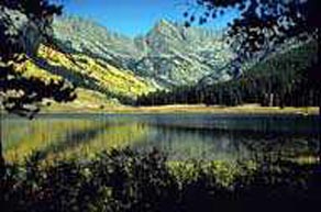
Rawah Wilderness contains sculpted glacial valleys with numerous lakes, located at the northernmost extent of the Front Range.
Melting snow fills 26 lakes within the area, lakes enticingly stocked with rainbow, cutthroat and brook trout. Island Lake and Crater Lake are especially lovely, shadowed by walls that stand approximately 1,000 feet above the water.
The range marks the northern terminus of Colorado's Front Range, and like much of the Front Range, the granite peaks and ridges of the Rawahs owe their sweeping valleys and abundant lakes to the action of glaciers.At the Rawah's southern end, spruce-fir forest dominates, including many areas determined to be old growth. Continuing lower in elevation, the spruce-fir ecosystem gives way to dense stands of lodgepole pine that blanket the range's gentler slopes. As is common with lodgepole pine forests, the fire history of this portion of the wilderness is one of large conflagrations.
Hunters favor the lower elevations of the Rawahs for the healthy populations of deer and elk found there. Less common species include bighorn sheep and moose, which were reintroduced in the 1970's and '80s by the Colorado Division of Wildlife.
Rawah was one of Colorado's five initial wilderness areas designated by the 1964 federal Wilderness Act. The designation included a tiny 27,000 acre core that was enlarged by another 50,000 acres with the passage of the 1980 Colorado Wilderness Act.
Size: 73,068
Elevation: 8,400 to 12,951 feet
Miles of trails: 76
Year designated: 1964, 1980
Hunting areas: 6, 7, 171
For more information contact:
Arapaho & Roosevelt National Forests, 240 W. Prospect Rd., Ft. Collins, CO 80526-2098 (970)498-2770 Supervisor's Office
Boulder Ranger District, 2140 Yarmouth St., Boulder, CO 80303 (303)444-6600 Boulder District
Canyon Lakes Ranger District, 240 West Prospect, Ft. Collins, CO 80526 (970)498-2770 Canyon Lakes District
Clear Creek Ranger District, PO Box 3307, Idaho Springs, CO 80452 (303)567-2901 Clear Creek District
Sulphur Ranger District, PO Box 10, Granby, CO 80446 (970)887-4100 Sulphur District
For more information contact:
Routt National Forest, Supervisor's Office, 2468 Jackson St., Laramie, WY 82070-6535 (307)745-2300 Fax:(307)745-2398
Hahns Peak - Bears Ears Ranger District, 925 Weiss Drive, Steamboat Springs, CO 80487-9315 (970)879-1870 Fax:(970)870-2284
Parks Ranger District, PO Box 158, 100 So. Main St., Walden, CO 80480 (970)723-8204
Craig Interagency Dispatch Center, 455 Emerson St., Craig, CO 81625 (970)826-5037 Fax:(970)824-6084
Yampa Ranger District, 300 Roselawn Ave., PO Box 7, Yampa, CO 80483 (970)638-4516 Fax:(970)638-4635

NOTE: coloradowilderness.com gratefully appreciates the eloquent descriptions of our wilderness areas provided by Mark Pearson, author of "The Complete Guide to Colorado's Wilderness Areas", Westcliffe Publishers, Englewood, CO. The book also contains many beautiful pictures by renowned photographer and Colorado resident John Fielder.
info@coloradowilderness.com
Site designed and maintained by IOR Productions, PO Box 540, Meeker, CO 81641Copyright 1999 IOR Productions. All rights reserved.
|